All the areas in South Warwickshire earmarked for new homes in the local plan
By James Smith 12th Jul 2026

As the South Warwickshire Local Plan (SWLP) reaches its latter stages, we have taken a look at all the areas earmarked for new homes and employment land.
Warwick and Stratford-on-Avon District Councils have released their latest draft of the plan, which includes provisions for tens of thousands of new homes across the region.
New estates are split across 'strategic growth locations' (next to existing towns) and two 'new settlements' where villages could see a huge amount of development.
Locals are set to have their final say on the SWLP before it is submitted to the secretary of state for approval.
As well as new homes, SWLP also includes plans for new roads, schools, employment land and more.
Councillors are due to discuss the latest draft of the plan next week.
Here is a run down of each of the areas allocated for more homes, starting with the two potential new settlements.
Download our Nub News App!
- It’s FREE and available now- Breaking news notifications
- Your Town in Your Pocket


Size: 262.36 hectares
Time Scale: From 2032/33 to 2056/7
Allocation could include:
- A minimum of 4,558 new homes, 4,000 of which will be delivered within the plan period to 2050.
- Up to 5,250 homes may be delivered depending on further master planning.
- Two three forms of entry primary schools.
- One six-form of entry secondary school.
- Provision of one district centre and three neighbourhood centres with retail, food and drink establishments, healthcare provision, community facilities, a library, other local services/amenities, mobility hubs and workspace opportunities
- A minimum of two hectares of local employment provision
- New spine road
- Sports provision
The land would be delivered in three phases.
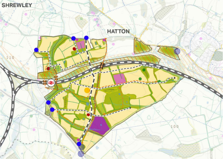
Long Marston Airfield New Community
Size: 697 hectares
Time Scale: Delivery of development across the wider site would commence following opening of the Stratford-upon-Avon Bypass (anticipated in 2035)

Allocation could include:
- Minimum of 10,300 new homes, with at least 4,500 built by 2050
- 15 hectares of non-strategic employment land
- 21 pitches for gypsies and travellers across at least two sites
- Four, three-form entry primary schools
- One secondary school
- Land reserved for second secondary school
- One district centre and three local centres, incorporating convenience retail, employment, health and community facilities
- Transport hub and safeguarded land for railway station
Bidford-on-Avon
Size: 217.7 hectares
Time Scale: From 2033 to 2050
Allocation could include:
- A minimum of 2,225 dwellings
- Land for a secondary school
- Land for up to two primary schools
- An early years facility
- A local centre
- Employment land
- A discount food retailer
- Care, assisted living, and retirement facilities
- Eight pitches for Gypsies and Travellers
Bishop's Tachbrook - Land to West
Size: 41.18 hectares
Time Scale: 2030/31-2037-38

Allocation could include:
- A minimum of 655 new homes
- New primary school
- Community space
- Local centre
- Extensive green infrastructure.
Bishop's Tachbrook - Land to Southwest
Size: 160 hectares overall, with approximately 121 hectares for strategic employment use.
Time Scale: 2027-2034/35
Allocation could include:
- New motorway junction to replace junctions 13 and 14 of the M40
- Access to Warwick and Leamington provided via a new dual-carriageway link road through the site.
- The new junction will include a new bridge across the motorway, providing access to employment areas set within green and blue infrastructure on both the western and eastern sides of the M40.
- A gateway development of approximately 121 hectares of strategic employment land comprising 3,750,000 sq ft of employment floorspace.
Bishop's Tachbrook - Land North West
Size: 122 hectares
Time Scale: From 2028/29 to 2040/41

Allocation could include:
- 1,720 dwellings
- Approximately 74 hectares available for public open space.
- Approximately two hectares of land for a two-form of entry primary school
Land at Gaydon
Size: 588 hectares
Time Scale: Employment development to be delivered within the plan period.
Allocation could include:
- Approximately 157 hectares of strategic employment land
- 81 hectares of non-strategic employment land.
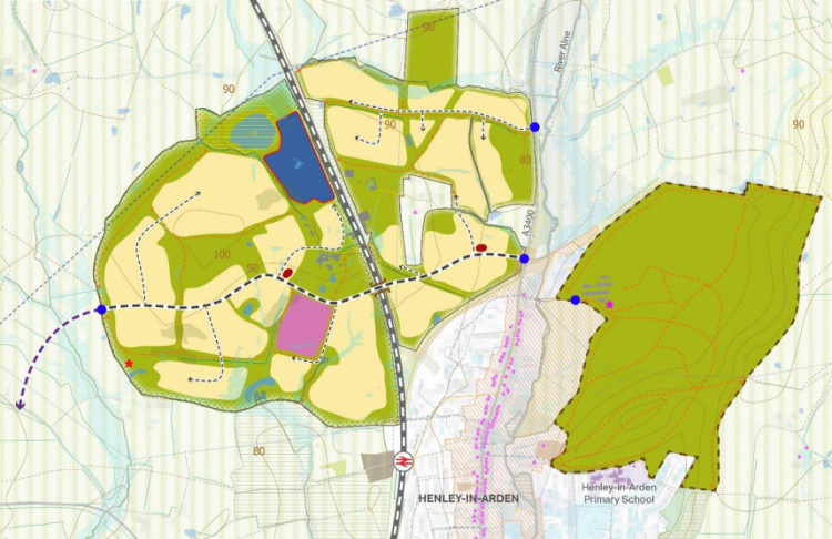
Henley in Arden
Size: 125.3 hectares
Time Scale: Not specified

Allocation could include: 2029/30 - 2044/45
- Minimum of 2,084 homes
- 3.3 hectares of employment land (research, development and office uses).
- Land for community and leisure uses including a two-form entry primary school, medical centre, allotments, sports and leisure, Public Open Space and new country park at Beaudesert Country Park
- A new link road to connect the site through from the A3400 Birmingham Road to the A4189 Henley Road will be provided, incorporating a vehicular rail bridge over the railway line. Improved pedestrian access and cycling routes will be provided to the town centre and Henley Railway Station
- Nine pitches for gypsies and, to be located in accordance with the accompanying masterplan
- Expansion of existing secondary school and provision of sixth-form at Henley-in-Arden School
- Allotments to be provided on-site
- Town square
- Health and community centre
- Improvements to Henley Railway Station
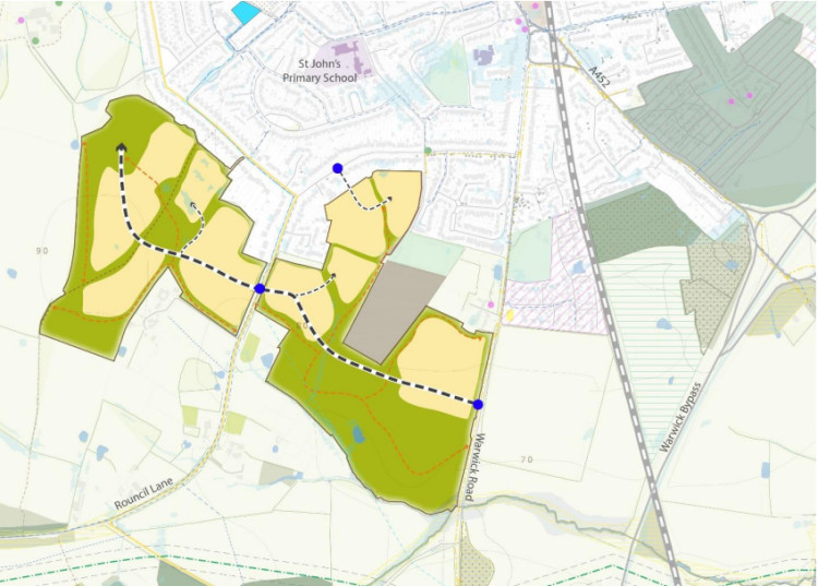
Kenilworth - Land to the south
Size: 60 hectares
Time Scale: From 2029/30 to 2036/37
Allocation could include:
- A minimum of 776 new homes and public open space.
- Funding contributions towards off-site primary, secondary and specialist education facilities, health services.
- Contributions to support and expand the Demand Responsive Transport 'IndieGo' service
- Link into the National Cycle Network Route 52 on Rouncil Lane and Rounds Hill
- Provision of allotments to expand upon the existing St John's allotments.
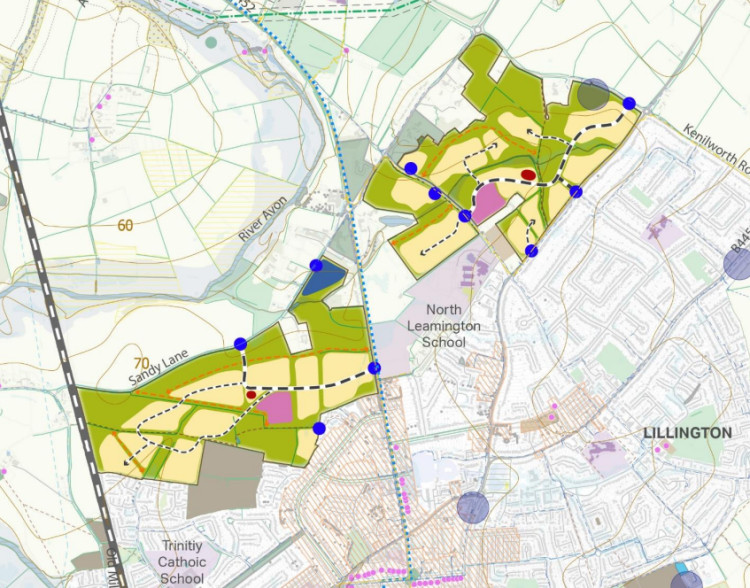
Leamington Spa - Land to North (Blackdown)
Size: 72 hectares to be released from the Green Belt
Time Scale: 2031/32-2041/42
Allocation could include:
- A minimum of 1,043 dwellings to be delivered across approximately 37 hectares
- Approximately 35 hectares of public open space, including areas of play, biodiversity, and public rights of way.
- A community hub/local centre
- On-site provision of a two-form entry primary school across approximately two hectares of land.
- Land to be safeguarded for the expansion of North Leamington School if required.
- Approximately 35 hectares with extensive open space, including sport pitches, allotments, community orchard and play areas.
Leamington Spa - Land to North (Milverton)
Size: 76 hectares to be released from the Green Belt
Time Scale: 2032-2045
Allocation could include:
- A minimum of 974 dwellings to be delivered across approximately 38 hectares with additional supporting infrastructure
- One hectare for provision of a food store providing up to 15,000 sq.ft of floor space.
- Provision of approximately 0.35 hectares for a mixed-use local centre with a range of potential uses as required by NHS Coventry and Warwickshire ICB and other providers.
- Approximately 2.35 hectares for on-site provision of a two-form entry primary school.
- A minimum of 38 hectares of multifunctional green infrastructure, incorporating structured landscaping, formal/informal open space, sports pitches, play facilities, community orchard and SuDs.
Leamington Spa - Land to East (Lillington)
Size: 83 hectares
Time Scale: 2031/32-2040/41
Allocation could include:
- A minimum of 1,455 dwellings across 38 hectares, with affordable housing provided
- The development will act as a model of sustainable living, contributing to a net-zero future and embracing principles of a 20-minute neighbourhood
- 458 affordable homes to be provided
- Local centre providing a range of uses to meet the needs of existing and future residents.
- Two-form primary school
- Public Open Space, including a new Cubbington Community Park.
- "It will be vital for development to ensure the delivery of a network of walking and cycling links between Lillington, Cubbington and Newbold Comyn."
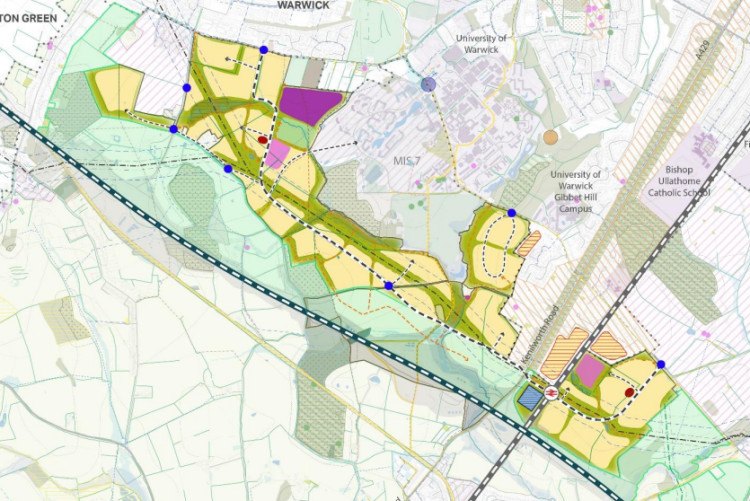
Size: development area = 294 hectares. Biodiversity enhancement area = 236 hectares
Time Scale: 2030 to 2050 and beyond
Allocation could include:
- 4,015 dwellings to be delivered up to 2050 (with a total capacity of approximately 4,500 dwellings
- Two, two-form entry primary schools with extra land to expand to three forms
- One six-form entry secondary school and post 16 provision
- Two neighbourhood centres to deliver retail, food and drink establishments, health provision (including GP provision as identified through the IDP), and other local services/amenities as required
- A contaminated land assessment will be required for the land south of Gibbet Hill Road to address the impacts associated with the historic landfill
Coventry Airport
Size: 117.27ha
Time Scale: Not stated
Allocation could include:
- This site is to be released from the green belt
- Allocated as a strategic site of sub-regional and regional significance to support the growth of the advanced manufacturing and engineering sector and associated innovation activities
South of Coventry (Kings Hill)
Size: 269 hectares
Time Scale: 2030 to 2050
Allocation could include:
- A minimum of 4,000 dwellings
- Two, two-form entry primary schools with space for a third form
- Six-form entry secondary school with post 16 provision
- Two neighbourhood centres. One will include provision for a community centre and GP surgery.
- Spine road
Southam – Land to East
Size: 201.3 hectares
Time Scale: 2028-2045.
Allocation could include:
- A minimum of 3,122 dwellings to be delivered across 201.3 hectares
- 8.32 hectares of employment land
- 13 Gypsy and Traveller pitches
- One Secondary School
- Three two-form entry primary schools with scope to expand
- Two local centres, incorporating convenience retail, health and community facilities.
Stratford-upon-Avon – Land to North
Size: 37.67 hectares
Time Scale: 2029/30 to 2037/38
Allocation could include:
- Minimum of 777 dwellings comprised of a mixture of sizes and types of dwellings
- Four gypsy and traveller pitches.
- The provision of land for one new education facility to meet the needs of the town..
- New community orchards.
- Stratford-upon-Avon Park and Ride - two-storey decked car park with approximately 390 car parking spaces per floor.
- Direct links to Welcombe Hills Country Park including a café/tourism hub, retail offering and visitor parking
Stratford-upon-Avon – Land to south east
Size: 174.45 hectares
Time Scale: 2030/31 – 2048/49
Allocation could include:
- Minimum of 2,727 new homes.
- New secondary school
- Two new primary schools
- New spine road
- Mobility hub
- Multiple areas of public open space and supporting social infrastructure.
- On-site health facility within local centre
- Delivery of a new spine road through the site connecting Shipston Road and Banbury Road
- 15 Pitches for gypsies and travellers
- Land east of Shipston Road – two main access points to be taken from Shipston Road, likely via two, three-arm roundabouts
Stratford-upon-Avon – Land to West
Size: 64 hectares
Time Scale: 2028/29 – 2036/37
Allocation could include:
- Two sites - West Shottery and Land north of Evesham Road
- First site would include at least 687 homes, community hall and public open space
- Second site would have up to 130 homes and public open space
Warwick - Land to West
Size: 51 hectares (Non Green Belt)
Time Scale:From 2031/32 to 2040/41
Allocation could include:
- Delivery of a minimum of 850 dwellings in the period up to 2050
- A spine road connecting a new roundabout junction at Hampton Road and a new priority junction at Old Budbrooke Road
- A new pedestrian and cycle route via a linear north-south greenway will be provided and allow access to Warwick Parkway station to the north
Wellesbourne North
Size: 129 hectares comprising
Time Scale: 2033-2042
Allocation could include:
- A minimum of 1,331 dwellings to be delivered across 97 hectares
- Nine pitches for gypsies and travellers
- Two-form entry Primary School (with scope for expansion to three forms)
- Public open space, including areas of play, an outdoor sports pavilion, biodiversity, and public rights of way. 47.5 hectares
- Active travel links to Wellesbourne Centre.
- 47.5 hectares of employment land primarily in research and development and office use at University of Warwick
Stoneleigh Employment Group
Size: 188.3 hectares
Time Scale: 2030 to 2050 and beyond
Allocation could include:
- Delivery of 82.3 hectares of gross non-strategic employment floorspace
- Delivery of a new multimodal spine road through the site from Stoneleigh Road through the HS2 compound land and utilising HS2 legacy routes/infrastructure to deliver an alternative access to Stoneleigh Park
- 5.4 hectares of net additional floorspace (Use Class B2, B8 and E(g))
- 64.9 hectares of new employment floorspace (Use Class B2, Use Class B8 and Use Class E(g)(iii) uses and ancillary E(g)(i) and (ii) uses)
Download our Nub News App:
- It’s FREE and available now
- Breaking news notifications
- Your Town in Your Pocket


Share: